Geoscience Protecting the Public

Geoscience safeguards communities by predicting natural hazards, managing environmental risks, and supporting public health initiatives which minimizes disaster impacts, protects ecosystems, and ensures resilient infrastructure for a healthier future.
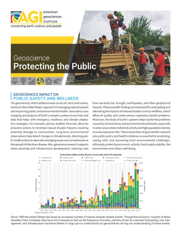
Geosciences Impact on Public Safety and Wellness

Earthquake Risk Assessment
Geologists and seismologists analyze faults and past seismic activity to forecast future earthquake risk, helping to inform building codes, urban planning, and disaster preparedness strategies.
Volcanic Eruption Monitoring
By studying volcanoes, geologists can predict eruptions and provide warnings to minimize loss of life and health impacts from ash, gases, and landslides, which are critical for nearby communities, the safety of air transport. Volcanoes can impact global weather and thus agricultural productivity.
Flood Prediction and Management
Geoscientists study river behaviors, human modifications to channels and weather patterns to predict floods, contributing to the design of flood defenses, and land-use planning to minimize impact on human health and property.
Wildfire Risk and Management
Through the study of landscape, ecology, and fire history, geoscientists help predict wildfire occurrences and develop strategies for controlled burns and land management that reduce the risk of large, uncontrollable fires, thereby protecting air quality and reducing the risk of landslides and erosion of valuable soils.
Climate Change Impact Assessments
Climate scientists analyze long-term weather patterns and trends to forecast changes in climate that can affect public health, infrastructure, agriculture, and water supplies, aiding in developing adaptation strategies.
Air Quality Monitoring
Geoscientists play a role in studying how natural events like dust storms and volcanic eruptions affect air quality. They also examine the dispersion of pollutants in urban areas, which is essential for public health advisories and regulatory measures.
Hazardous Materials Management
The study of how pollutants like heavy metals and chemical wastes behave in the soil and groundwater enables geoscientists to advise on the containment, clean-up, and environmental health impacts of these hazardous materials.
Coastal Erosion and Sea Level Rise
Oceanographers, geomorphologists, and geophysicists help predict changes in sea levels and storm surges, which are vital for coastal urban planning, protecting water quality, preserving ecosystems, and preventing loss of life from flooding.
Exemplars of Impacts of Geoscience on Natural Hazards and Public Health
Geoscientists, particularly seismologists and oceanographers, play a vital role in the development and operation of tsunami warning systems. These systems utilize networks of seismic and ocean sensors to detect undersea earthquakes that could potentially trigger tsunamis. By analyzing the seismic activity and water column changes in real-time, geoscientists can predict the arrival times and potential impact of tsunamis on coastal areas. This early warning capability is crucial for evacuating populations at risk, thus saving lives and reducing Loss of infrastructure from these destructive natural events.

Geoscientists contribute significantly to monitoring and improving urban air quality by studying the sources and dispersion patterns of pollutants. This involves tracking particulates from both natural sources, like volcanic ash, and human-made sources, such as vehicle emissions and industrial pollutants. By modeling how these particles travel through the atmosphere under various weather conditions, geoscientists help public health officials develop strategies for reducing exposure to harmful air pollutants, advising on the best times for outdoor activities and guiding policies on emissions reductions.
Hydrogeologists specialize in understanding the movement and storage of groundwater. Their expertise is crucial in preventing groundwater contamination, a major public health issue, especially in areas dependent on well water. By mapping aquifers and identifying contamination risks from agricultural runoff, industrial processes, and improper waste disposal, hydrogeologists help design effective safeguards and remediation strategies. These measures ensure the safety of drinking water supplies and protect aquatic ecosystems from the harmful effects of pollution.
Case Studies
 In the Northeastern United States, increased frequency of wildfires due to climate change poses significant risks. Geoscientists work on forecasting the occurrence and spread of wildfires, enabling better preparedness and response strategies that help protect public health and community resilience. The Northeast-Midwest Wildfire Risk Assessment Portal provides comprehensive data, user-friendly applications, and planning tools aimed at wildfire risk reduction. This tool helps federal, state, Tribal, and local communities prioritize areas for mitigation treatments, community education, and tactical analyses to effectively manage and reduce the risks associated with wildfires. The portal is a collaborative effort to streamline wildfire management across diverse jurisdictions in the Northeast and Midwest U.S.
Examples of Relevant Legislation and Policy
Executive Orders
- 14008: This order is comprehensive, focusing on integrating climate resilience into U.S. foreign policy and national security, establishing a White House Office of Domestic Climate Policy for a coordinated approach to climate challenges, and emphasizing the restoration of scientific integrity across federal decision-making. It highlights the need for clean energy transitions and environmental justice
- 13990: Signed to ensure science-based decision-making in federal agencies and to address the health and environmental impacts of industrial pollution, this order emphasizes environmental justice and aims to hold polluters accountable. It specifically directs the review and potential revision of regulations related to public health and environmental protections, including those impacting air and water quality.
Congressional Legislation
- 117th — H.R. 3684 Infrastructure Investment and Jobs Act: This major legislation includes provisions for climate resilience, clean energy, and water system improvements. It represents significant federal investment aimed at enhancing infrastructure in ways that also address environmental challenges.
- 117th — H.R. 5376 Inflation Reduction Act: Enacted in August 2022, this legislation commits nearly $369 billion to climate and clean energy efforts. It’s designed to reduce emissions, promote clean energy use, and enhance environmental justice initiatives through various funding mechanisms and tax incentives.
- 118th — H.R. 7916 Removing Nitrate and Arsenic in Drinking Water Act: amend the Safe Drinking Water Act to provide grants for nitrate and arsenic reduction projects.
Relevant Federal Agencies
- US Geological Survey
- Bureau of Ocean Energy Management
- Federal Emergency Management Agency
- Environmental Protection Agency
Related National Academy Reports
- Affordability of National Flood Insurance Program Premiums: Report 2 (2016)
- Assisted Resettlement and Community Viability on Louisiana’s Gulf Coast: Proceedings of a Workshop (2023)
- Benefits, Applications, and Opportunities of Natural Infrastructure: Proceedings of a Workshop—in Brief (2022)
- Climate Resilience and Benefit–Cost Analysis: A Handbook for Airports (2019)
- Framing the Challenge of Urban Flooding in the United States (2019)
- Implications of the California Wildfires for Health, Communities, and Preparedness: Proceedings of a Workshop (2020)
Non-Partisan Non-Profit Expertise
- American Geophysical Union
- American Institute of Hydrology
- American Institute of Professional Geologists
- Association of American State Geologists
- Association of Environmental and Engineering Geologists
- Geological Society of America
- National Groundwater Association
- Seismological Society of America
- Soil Science Society of America
- U.S. Permafrost Association