Geoscience’s Role in Building U.S. Influence Across the World

Geoscience fosters global collaboration by addressing transboundary resource challenges, climate change, and disaster resilience. These activities strengthen diplomatic ties, promote sustainability, and build a foundation for international stability.
Geosciences Impact on Diplomacy
Climate Change Agreements
Geoscientists provide essential information that shapes international climate policies and agreements. Their research helps to understand emissions impacts, global temperature trends, and the effectiveness of proposed mitigation strategies.
Water Resource Management
Geoscience expertise aids in the negotiation of transboundary water treaties and management strategies, essential for regions sharing water bodies and aquifers, ensuring equitable and sustainable use of water resources and conflict reduction.
Disaster Preparedness and Response
Geoscientists support international disaster response strategies by identifying natural hazards like earthquakes, tsunamis, and volcanic eruptions, enabling better preparedness and collaborative international response efforts.
Energy Resource Diplomacy
Knowledge of geology is crucial in discussions about the exploration and exploitation of oil, gas, and mineral resources, determining accurate assessments of reserves, and helping to form agreements that are economically beneficial while minimizing environmental impact.
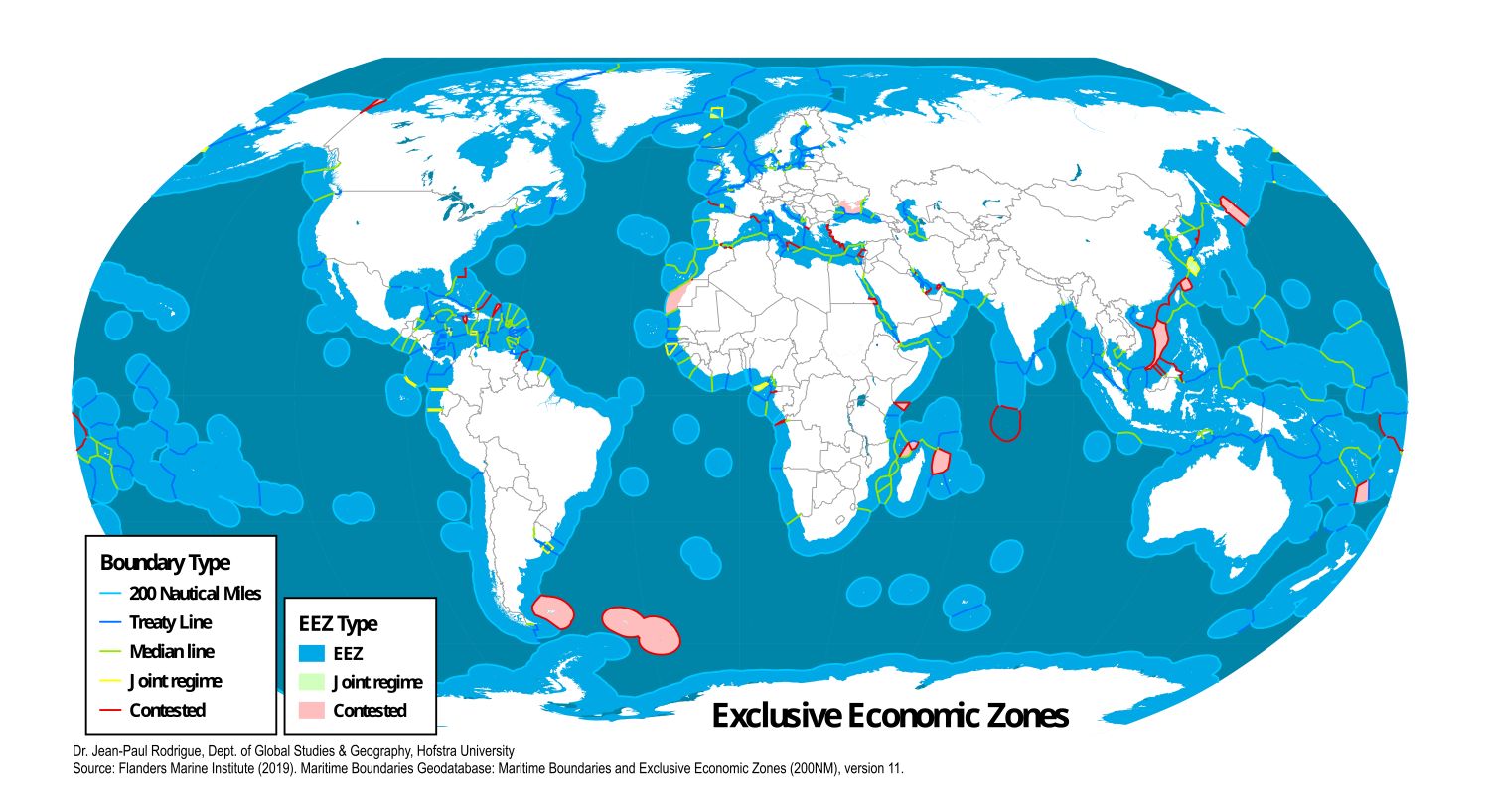
Maritime Boundaries and Oceanography
Oceanographers contribute to negotiations on maritime boundaries and the management of marine resources, including fisheries and mineral rights, which are vital for maintaining international maritime cooperation and legal frameworks.
Polar Region Affairs
Geoscientists are vital in shaping policies related to polar regions where issues ranging from climate research to territorial claims and resource exploitation require informed scientific input to guide international cooperation and treaties.
Atmospheric Pollution Control
Meteorologists and climate scientists provide critical data for international discussions on air quality and pollution control, helping to frame agreements that address cross-border pollution issues.
Nuclear Arms Control
Geoscientists lead the monitoring of underground nuclear tests. Their expertise supports international treaties like the Comprehensive Nuclear-Test-Ban Treaty (CTBT). This monitoring involves detecting and analyzing seismic activities that distinguish nuclear explosions from natural seismic events and maintains transparency and trust among nations in nuclear disarmament discussions.
Exemplars of Impacts of Geoscience on Diplomacy

Geoscientists specializing in hydrogeology are crucial in the negotiation and implementation of transboundary water treaties. An example is the U.S.-Mexico Transboundary Aquifer Assessment Program, where American and Mexican geoscientists collaborate to assess and manage water resources that span the border. This program relies on hydrological data to make informed decisions about water allocation, usage, and conservation, addressing both countries’ needs while ensuring sustainable water management practices. Such cooperation not only enhances water security but also strengthens diplomatic relations by promoting mutual interests and conflict resolution.
Seismologists contribute directly to international security and nuclear arms control by monitoring seismic activities associated with nuclear tests. Their expertise supports the verification processes under the Comprehensive Nuclear-Test-Ban Treaty (CTBT), which aims to eliminate nuclear explosions by all states. By detecting and analyzing seismic waves generated by underground nuclear tests, seismologists provide crucial evidence needed to enforce compliance with the treaty. This scientific monitoring helps maintain international peace and stability by preventing the proliferation of nuclear weapons and ensuring that countries adhere to their disarmament commitments.
Geoscientists play a pivotal role in shaping international climate policy through their contributions to the Intergovernmental Panel on Climate Change (IPCC). The IPCC gathers and synthesizes the latest geoscientific research on climate change, including data on atmospheric temperatures, oceanic cycles, and carbon sinks. This comprehensive body of knowledge helps in formulating global climate agreements by providing policymakers with a clear understanding of climate trends, potential impacts, and mitigation strategies. For instance, geoscientists’ input was instrumental in the development and adoption of the Paris Agreement, where nations committed to limit global warming to below 2 degrees Celsius above pre-industrial levels.
Case Studies
 The Volcano Disaster Assistance Program (VDAP), a partnership between the U.S. Geological Survey and USAID, provides expertise in volcano monitoring and disaster response worldwide. This program enhances volcanic crisis preparedness, helping vulnerable communities mitigate the impacts of volcanic eruptions and improving international relations through cooperative disaster management.
Examples of Relevant Legislation and Policy
Executive Orders
14008: Addresses the global climate crisis through coordinating domestic and international approaches.
Congressional Legislation
118th H.R. 5874: Reauthorizes the United States-Mexico transboundary aquifer assessment program.
118th H.R. 4443: A bill that both addresses the trade of minerals from the Democratic Republic of Congo relative to child labor and the relationship between the U.S. and Chinese interests in strategic minerals.
118th S.458: Establishes programs within Department of Energy and Interior, as well as with the Export-Import Bank to help secure mineral supplies for European partner nations and to coordinate with Mexico and Canada as partners in this effort to secure material independence for Europe from Russia.
Relevant Federal Agencies
- US Department of State
- US Department of Defense
- US Department of Energy
Related National Academy Reports
- Advancing Sustainability of U.S.-Mexico Transboundary Drylands: Proceedings of a Workshop (2018)
- China-U.S. Scientific Engagement: Key Issues and Possible Solutions for Sustainability and Planetary Health: Proceedings of a Workshop—in Brief (2023)
- Climate Security in South Asia: Proceedings of a Workshop (2023)
- Innovation, Global Value Chains, and Globalization Measurement: Proceedings of a Workshop (2022)
- Operationalizing Sustainable Development to Benefit People and the Planet (2022)
Non-Partisan Non-Profit Expertise
- American Association of Petroleum Geologists
- American Geophysical Union
- American Institute of Hydrology
- American Institute of Professional Geologists
- American Meteorological Society
- Association of American State Geologists
- Association of Environmental and Engineering Geologists
- Center for Ocean Leadership
- Geological Society of America
- Mineralogical Society of America
- National Groundwater Association
- Society of Economic Geologists
- Society of Exploration Geophysicists
- Society for Mining, Metallurgy, and Exploration
- Soil Science Society of America